-
History
The first stage of Glenmaggie was built between November 1919 and 1926 and held 132,000 ML when full.
After World War 2, extra water was required to enable returning soldiers to settle on land and farm within the district. This was achieved by raising the wall 3.6 metres, by placing 14 radial gates along the top of the original wall. This increased its capacity to 177,640 ML.
In 1987 the dam was strengthened to withstand major floods and earthquakes by drilling through the wall into the bedrock and installing 70 re-stressable steel cables. This effectively tied the wall to the ground to resist overturning.
Purpose
The lake harvests water for use in our gravity irrigation systems to properties in the Macalister Irrigation District, near the towns of Maffra, Heyfield and Stratford and the City of Sale.
The Glenmaggie dam wall, which creates the lake, is a mass concrete overfall dam with irrigation outlets on both sides of the river serving irrigation channels. The central portion is an overfall spillway.
The Macalister Irrigation District covers about 53,000 hectares around the Macalister and Thomson Rivers, extending from Lake Glenmaggie to Sale. It comprises two areas: the Maffra-Sale Irrigation Area to the north of the Thomson River and the Central Gippsland Area (including the Nambrok-Denison Soldier Settlement district) to the south.
To distribute the water from Lake Glenmaggie, three main channels have been constructed: the Main Northern (capacity 600 ML/d), the Main Southern (capacity 1,470 ML/d) and the Main Eastern (capacity 340 ML/d). The Main Southern is supplemented by flow from the Cowwarr Channel diverted from the Thomson River at Cowwarr Weir.
-
Statistics
RESERVOIR Capacity 177,628 ML Dead storage 4,860 ML Surface area 1,760 Ha Full supply level 77.1 m AHD Catchment area 1,891 km2 EMBANKMENT Maximum height 37.2 m Length 293 m SPILLWAY Crest length 120 m Discharge capacity 300,000 ML per day
-
Power generation
In 1994 Pacific Hydro installed a small generation station at Lake Glenmaggie with twin turbines, giving a total capacity of 3.8 megawatts, which supply power to the state network.
These are driven by releases to the Macalister River and Southern Channel, and provide an environmentally friendly source of power generation. The intake and offtake pipes into and out of the turbine house are clearly visible from the dam wall recreational area.
For more information please visit Pacific Hydro.
-
Lake Glenmaggie managing floods
The Macalister Irrigation Area (MIA) is a vital part of Gippsland’s local economy. The dairy industry produces some 400,000,000 litres of milk, returns around $150 million at the farm gate and grosses approximately $500 million annually. The MIA also supports other important industries including vegetable and beef production and fodder cropping. It is estimated that these activities generate almost $650 million into the local economy.
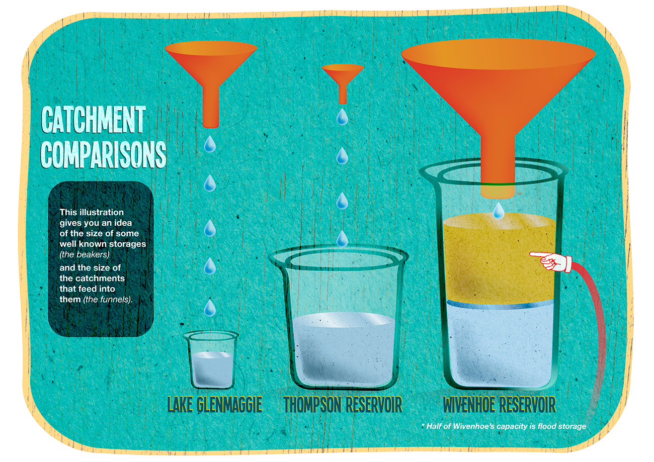
The success of the irrigation area requires a secure and reliable water resource. The primary source of water for the MIA is Lake Glenmaggie, which sources its water from the Macalister River catchment, located to the north of the storage. Lake Glenmaggie is relatively unique amongst large storages in Victoria, in that it fills and spills on average in nine out of ten years. As a comparison, the Thomson reservoir, Melbourne’s primary water source, has a catchment area only 25% of Lake Glenmaggie but has a storage capacity five times greater.
Lake Glenmaggie was built in the 1920s and its height was raised in the 1950s with the establishment of 14 flood gates. These gates can only be operated when the reservoir level reaches 119,174 ML, or about 70% of capacity.
Large river flows leading to floods are not uncommon on Gippsland rivers and they occur regularly. Flood severity is increased when bushfires reduce the vegetation in the catchment, as we experienced in the 2006/07 bushfires.
When floods occur, we have a number of objectives to meet – ensuring the safe operation of Glenmaggie Dam, retaining water for future irrigation and to manage the effects of flooding downstream. Lake Glenmaggie’s large catchment means that river flows can be quite extreme, so even when the reservoir is only partly full we can have limited ability to reduce the impact of floods downstream. At such times, we work with the emergency services agencies to help ensure that downstream communities are well informed.
Where the risk of a rainfall event is identified, we maintain close contact with the Bureau of Meteorology to understand what is expected and the maximum rainfall that is forecast. We also review different scenarios for the runoff and likely inflows from the expected and maximum rainfall. At this stage we also undertake the necessary staffing arrangements to run our operations 24 hours a day.
During a rainfall event we are constantly planning for releases from the storage. These are based on actual and expected rainfall levels, stream flow measurements taken upstream from Lake Glenmaggie and calculated inflows into Lake Glenmaggie, based on the actual storage level. Our objective is always to reduce the severity and duration of any flood.
Leading up to and during flood events we work closely with the Bureau of Meteorology, State Emergency Service and other emergency services to provide regular updates on the current and projected situation, and to assist them with setting actions, such as warnings, public meetings and evacuations where required. We also support the Macalister flood warden system – set up for the community, by the community following the 1971 floods.
We strongly recommend that if you are in a flood prone area that you and your family should familiarise yourself with the SES’s flood information and take all necessary precautions.
-
How does Lake Glenmaggie compare?
This illustration shows the catchment size and storage size of Lake Glenmaggie in comparison with the Thompson Dam in Victoria, and the Wivenhoe Dam in Queensland.
Location
Lake Glenmaggie is located on the Macalister River in Central Gippsland, Victoria – VicRoad Reference Map 82 E8