Expressions of interest closed for groundwater in south west Victoria’s deep aquifers
Introduction
Expressions of interest closed at 4pm Friday 2 May 2025 for securing groundwater in Lower Tertiary Aquifers (the Dilwyn Formation and deeper aquifers) within the boundary of the Warrnambool Zone and Dilwyn Formation (Lower Tertiary Aquifer) Paaratte Groundwater Management Area (GMA).
We have finalised the initial assessment of the expressions of interest received and as a result of the level of interest indicated, Southern Rural Water will be holding a water auction in both the Warrnambool Zone and the Paaratte Groundwater Management Area to distribute the available water in a way that promotes fairness.
The timing of the auctions are yet to be finalised however we expect it will be early in September 2025.
We will confirm the timing and provide further detail regarding the process and indicative costs in the coming weeks.
Important note: If individuals are successful in securing water at the auction, this does not guarantee Southern Rural Water will be able to issue a licence as this is dependent on the outcome of a full licence assessment process which could include hydrogeological assessments or pumping tests.
Due to this uncertainty, those successful at auction will not be required to pay the full purchase price immediately, however there will be a non-refundable deposit required to ensure Southern Rural Water can adequately recover the costs of the assessment process.
Warrnambool Zone
The total allocation available is 5,000 megalitres. Please note this aquifer is generally deeper than 400 metres below the surface, and it would require substantial time and financial investment to secure all relevant licences and install a bore to access this groundwater.
The boundary of the Warrnambool Zone is shown in the map. To be eligible you must own or occupy property within this boundary. If you are unsure if your property is within the boundary, please contact us and we can make an assessment.
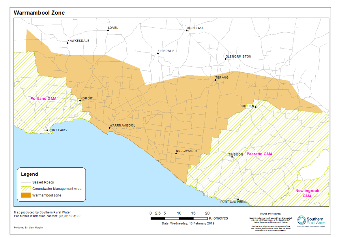
Read our Warrnambool technical information sheet for details on boundaries, approximate depth to the top of the aquifer, and potential yield and salinity.
Paaratte GMA
The total allocation available is 1,400 megalitres. Please note this aquifer is generally deeper than 400 metres below the surface, and it would require substantial time and financial investment to secure all relevant licences and install a bore to access this groundwater.
The boundary of the Paaratte GMA is shown in the map. To be eligible you must own or occupy property within this boundary. If you are unsure if your property is within the boundary, please contact us and we can make an assessment.
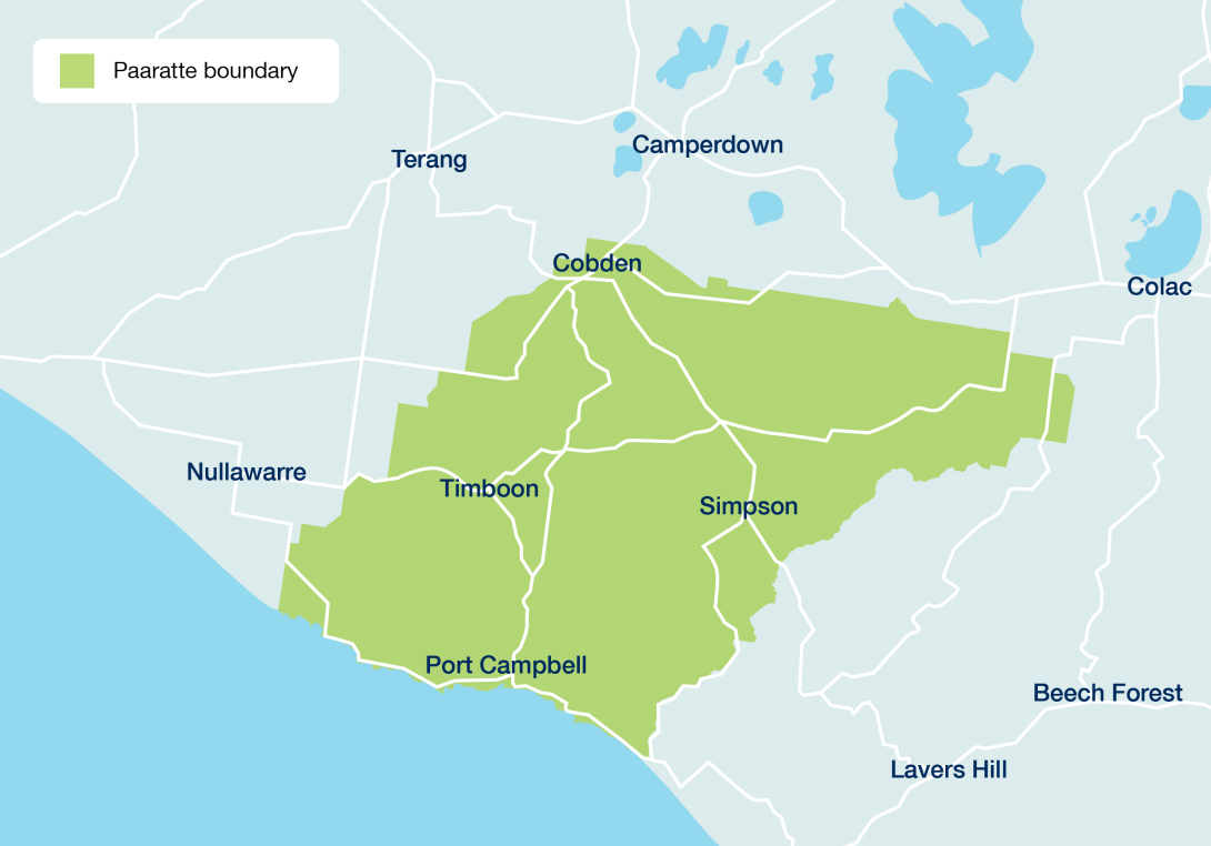
Read our Paaratte technical information sheet for details on boundaries, approximate depth to the top of the aquifer, and potential yield and salinity.
FAQS
-
What water is available?
5,000 megalitres is available in the Warrnambool Zone of the Lower Tertiary Aquifer system (this includes the Dilwyn Formation and other deeper aquifers) and 1,400 megalitres in the Paaratte Groundwater Management Area (GMA) – this is within the Dilwyn Formation only.
-
How deep is the aquifer?
Drilling depths to the top of the Dilwyn Aquifer vary depending on location.
The Paaratte GMA targets the confined Dilwyn Formation. Depths are greater than 120m in the east around the Swan Marsh and Irrewillipe areas and deepen moving west with the top of the aquifer over 400m below surface at the coast.
In the Warrnambool Zone, a limited number of deep production bores have been constructed in the Dilwyn Formation across south-west Victoria. Drilling depths are likely to vary between 500m and 1,000m+. The aquifer is generally deeper than 400m below the surface.
To determine whether your property is within the boundaries and to understand likely drilling depths please contact Southern Rural water on 1300 139 510
-
How do I express an interest in securing groundwater?
Expression of interests have now closed. To be notified of the auction, please keep an eye on our website, or email srw@srw.com.au and advise you’d like to be notified when the auction is taking place.
-
What happens after the expression of interest process
The expression of interest has now closed. Southern Rural Water have determined that water will be made available via an auction to eligible individuals. We will provide further details on the auction in the coming weeks.
-
I didn’t submit an expression of interest, can I participate in the auction?
If you did not submit an expression of interest please contact us on 1300 139 510 or email srw@srw.com.au as soon as possible to discuss your options. In order to participate in the auction we must determine your eligibility.
-
How soon can I access water if I successfully secured it through auction?
If you are successful in purchasing a volume of water at auction, Southern Rural Water are still required by law to undertake a full licensing assessment for both the take and use (section 51 licence) and operation of works (section 67 licence).
All applications will require neighbour notification processes and be referred to stakeholder agencies (e.g. Catchment Management Authorities) for consideration and comment.
This application process may require a pumping test, an irrigation and drainage plan to be developed and the provision of other technical evidence to support the application.
This process can take between 3 months and 12 months.
We cannot guarantee application approval and would strongly advise you talk to us before applying so we can advise you before you commit to the application process.
-
How will the auction be run?
The auction will be held online on Southern Rural Water’s auction platform hosted by Water Partners. We will provide more information regarding participation at auction in the coming weeks.
-
What technical information is required to support an application?
This can vary depending on the complexity and magnitude of the application. At a minimum we require a desktop hydrogeological assessment to provide information around the likely impact of the intended water use on surrounding users, and the environment.
Depending on the nature of your application, you may be required to do a pump test to help us better understand impacts on other users, prepare an irrigation drainage plan and possibly secure Environmental Protection Agency waste approvals.
-
How much will this water cost?
The water resource is located deep beneath the surface. The costs to secure the relevant licences and drill a bore to access this groundwater is likely to be significant.
You will need to use the services of hydrogeological consultants to help prepare application materials. The fees of consultants can vary and will depend on the scope of work required.
The cost to drill a production bore in these deep aquifers could be in the range of $500,000 to $1,000,000 depending on the depth of the bore and the materials used. We advise seeking advice from a driller to get greater certainty on these costs.
-
What are the costs associated with purchasing this water?
The market will decide the price of water at the auction. Along with the price of water, you successful bidders will be required to pay the application fees set out below:
- Fixed Component (for applications over 400 megalitre) - $4069.52
- Volumetric Component - $24.76 per megalitre
Annual fees will be charged regardless of the mechanise used to allocate water. These are set out below:
- Fixed Licence Fee $418.90
- Volumetric - $4.60 per megalitre