Groundwater Management Information
Use the map below to find out more about individual Groundwater Management Areas and Water Supply Protection Areas – click on the map to find the relevant page for more information.
-
Groundwater basics
What is groundwater?
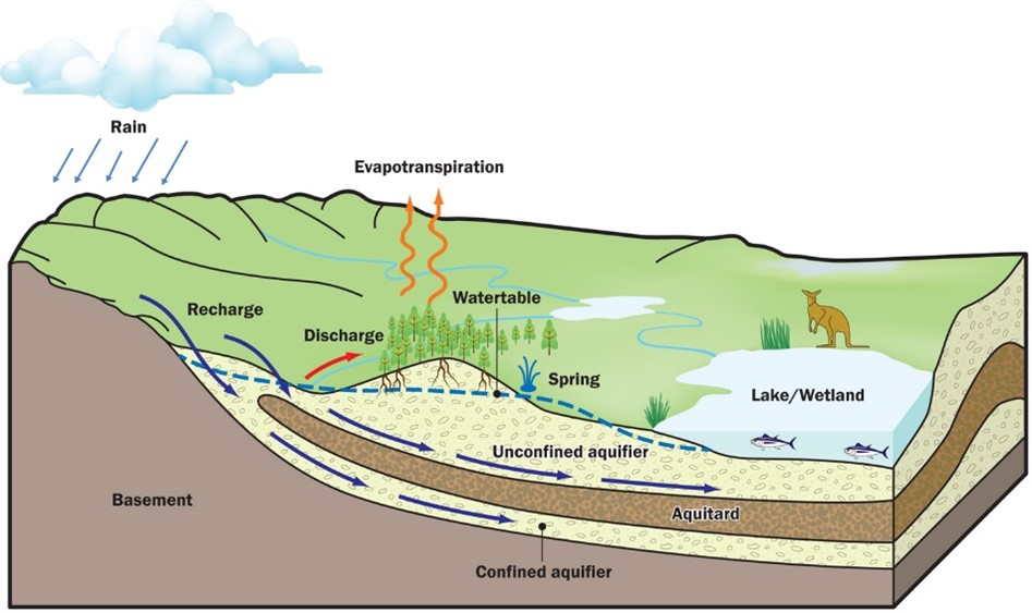
Groundwater is water that is found below the ground surface. About 30% of the world’s fresh water is stored as groundwater while less than 1% is stored in streams, rivers, lakes and other surface water bodies. It is stored in and flows through aquifers and, to a lesser degree, aquitards.
What are aquifers and aquitards?
An aquifer is a layer of fractured rock, gravel, sand or limestone below the ground surface with enough space between the particles to hold groundwater and allow it to flow through. An aquitard is a layer of rock or clay below the ground surface that is tightly compacted and so water cannot easily be held within it or flow through it.
What are unconfined, confined and semi-confined aquifers?
Where the aquifer material between the ground surface and the water table is porous it is known as an unconfined aquifer. Where an aquifer is overlain by an aquitard it is known as a confined aquifer. Semi-confined aquifers occur near the edge of the confining layer (or aquitard) or where the aquitard is very thin or more permeable allowing more water to move through it. Unconfined and confined aquifers react differently to change.
Aquifers and the water cycle
This diagram shows a cross section of aquifers and aquitards and a basic water cycle. Diagram: ©Spatial Vision Innovations Pty Ltd (2015)
Groundwater Management
Why is it managed?
Groundwater is a valuable resource because it is generally a very reliable source of water that persists during dry periods when streams can run dry. It is also a much less expensive option than building large dams. Its reliability also makes it important for some ecosystems that depend on it during dry periods.
How is groundwater managed?
Groundwater is managed within a licensing framework that records user information, measures and records groundwater levels, meters use and applies rules such as caps on allocation, restrictions in dry seasons and transfers.
How are bores managed?
A licence is required to drill a bore. This is to ensure that construction is undertaken by a licensed driller and complies with Australian drilling standards. Records of bores that include the owner, driller, location, depth of bore, geology and any water quality sample results are stored on a database – the Water Measurement Information System.
How is groundwater use regulated?
With the exception of water used for domestic and stock purposes, all groundwater use is licensed. Licences have fixed annual volumes and compliance is ensured through metering usage and field inspections.
How are aquifers managed?
Aquifers are managed differently according to their identified risks and how they react to use and climate. These risks include things such as the impact of falling groundwater levels on bores or Groundwater Dependent Ecosystems (GDEs) or the potential for saline intrusion. Where there is a high level of identified risk or where there is a high number of users Groundwater Management Units (GMUs) exist to ensure that the aquifer is managed sustainably by defining areas with caps on allocation and rules that relate to transfers and pumping restrictions. Local Management Plans explain how these caps, rules and restrictions apply.
Who is responsible?
Under the Water Act the Minister delegates authority to Southern Rural Water to administer the regulations around licensing that protect groundwater resources. This includes:
- Issuing works licences (bore construction)
- Issuing new ‘take and use’ licences
- Temporary transfer of a licence (trading)
- Permanent transfer of a licence (trading)
- Amendment to a licence
- Surrender of a licence
- Amalgamation of licences
- Approval to dispose of matter underground
- Setting allocation caps
- Setting trading rules and other restrictions on the ‘take and use’ of groundwater
The Department of Energy, Environment and Climate Action (DEECA) oversees resource management and state policy. RWCs report information on licence volumes and use within groundwater catchments and basins to DEECA. There are several other agencies with important roles in groundwater management.
Groundwater Monitoring
How is groundwater monitored?
Groundwater is monitored by a network of observation bores. These bores are part of the State Observation Bore Network (SOBN). The information collected from the SOBN is added to a database and analysed using hydrographs. Other information such as metered groundwater use, and rainfall can be used to help interpret hydrographs. Water quality is tested in all new bores and more regularly in some observation bores.
Aquifers in Southern Victoria
Groundwater is found in aquifers. An aquifer is a layer of fractured rock, gravel, sand or limestone below the ground that is porous enough to hold groundwater and allow it to flow. An aquitard is a layer of rock or clay that may hold some groundwater but is not porous enough to allow it to flow significantly.
Southern Victoria can be broadly subdivided into three aquifer layers; the upper, middle and lower aquifers. The aquifer layers are generally separated from one another by aquitards. A cross section showing the relative position of the aquifer layers in the western, central and eastern parts of our area is provided in Figures 1,2 and 3. Further information on these aquifers can be found in Southern Rural Water's Groundwater Atlas which can be found below in the "Links and Resources" section.
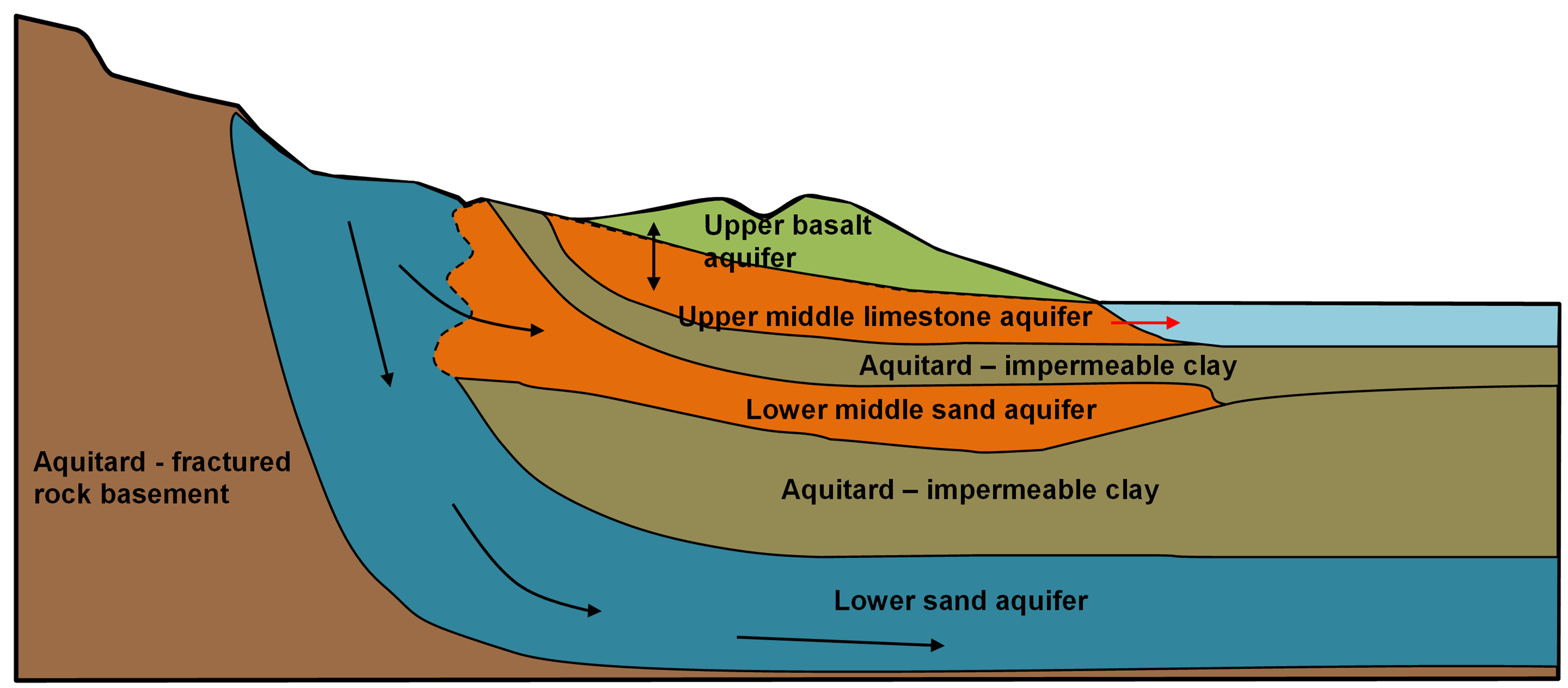
Cross-section showing the relative position of the aquifer layers (taken from the South West Victoria Groundwater Atlas).
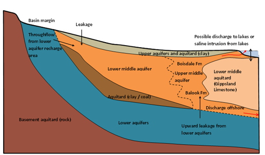
Cross-section showing the relative position of the aquifer layers (taken from the Gippsland Groundwater Atlas)
For Groundwater prices and forms click here.
-
FAQs
Can I drink groundwater?
IMPORTANT: We recommend that you DO NOT drink groundwater unless it is treated.
The quality of groundwater can vary widely from place to place and should not be considered safe for human consumption without proper treatment.
Can I use groundwater for domestic and stock?
The Water Act 1989 says that anyone in the state can take domestic and stock water from a river or bore that they can access. Please visit our domestic and stock page for more information.
What are my responsibilities as a groundwater user?
You must ensure that your water is fit for purpose. You should also make sure your bore is maintained in proper working order to protect against bore failure. If you have a ‘take and use’ licence you must adhere to the conditions of your licence.
Renewing your water licence
If your water licence expires, you won’t be able to take and use water.
Water Act 1989 sections 58 and 72 allow for a licence holder to apply to renew their licence before it expires. Around March of each year, we will send you information on what you need to do to renew your licence. Below is a list of some frequently asked questions:
Why do I have to renew my licence?
Your licence to take and use water and to operate works is valid for a fixed term (usually for several years, ending on 30 June in the year of expiry). If you wish to keep the licence, the Water Act 1989 states that you must apply to renew it before it expires.
Why haven’t I had to renew my licence before when I have had it for so long?
All licences are reviewed toward the end of their term. It could be that your licence was issued 15 years ago and this is the first time it has been due for renewal.
How do I renew my licence?
You need to:- review the information SRW provides you
- advise us of any changes, and
- pay the application fee (if required)
When does my licence expire?Your licence expires on 30 June – the actual year it expires will be outlined on your licence. If you want to continue to take and use water and to operate your works, you must submit an application to renew before the expiry date of your licence. If you do not lodge your application with us before the expiry date, you will no longer have authorisation to take and use water.
How long will my licence be renewed for?
Our aim is to renew your licence for 15 years, however, we may consider a lesser time in situations where the impacts of taking water are uncertain.
What if I no longer need my licence?
If you don’t need or want your licence any more, talk to us about your options:
- you may be able to trade your licence on a temporary or permanent basis
- you can surrender your licence. Any outstanding fees must be settled before a licence can be cancelled.
What if the licence is not in my name or the licence owners have changed?
Water licences are ‘owned’ by the people named on the licence. If the name on a licence has changed, you will be asked to complete a ‘transfer of ownership’ application form. All those people listed on the licence must agree and sign the “transfer of ownership” application form.
What if the named licence holders have died?
In this instance, a licence can usually be updated if one of the surviving licence holders provides us with a death certificate, will or probate information. If all named licence holders are deceased, the executors of the estate will need to submit a ‘transfer of ownership’ application to us. We would also require a copy of the will to verify that the new licensees are the people named in the will.
What if I have sold the land but not the licence – can I still renew for 15 years?
No. If the land noted on a licence has been sold to another person (and not replaced) you cannot renew for 15 years. However, to allow you enough time to transfer the licence, the licence may be renewed for a maximum period of 12 months. We recommend you contact us if you are in this situation.
What happens when you apply to take and use water?
When we receive your application, we immediately:
- scan it and add it to our record keeping system
- send you a receipt for any fees you have paid, and
We then assign it to one of our Assessment Officers, who will see your application through to the end.
They will check your application to make sure that you have given us all we need to assess your proposal.
If something simple is missing, they will call you. If something more important is missing, they will write to you. We cannot work on your application until we have all of the details we need.
Assessing your application. The process explained
When we assess an application, we must think about:
- current water users, waterways and how close they are to you
- section 40 of the Water Act 1989
- government policies
- local management rules or plans
- irrigation development guidelines if they apply
The process explained Technical work
If necessary, we may ask you to provide technical information about your proposal. This often happens when we think your proposal may affect other users or the environment.
Asking for comment
If your proposal may affect other users or the environment, or is for a significant volume of water, we need to give people a chance to comment. We require you to:
- advertise your proposal in a local newspaper
- let your neighbours know about your application by formal letter
We will provide you with templates for the required advertising and neighbour letters.
We will also refer your application to agencies such as the catchment management authority, local council, urban water authority, Aboriginal Affairs Victoria and Department of Environment, Land, Water and Planning.
The public and agencies have 28 days to provide comments.
If we receive several adverse comments, we may invite all interested parties to a meeting. This gives people a chance to:
- discuss the proposal in more detail
- talk about any concerns
If you have given us expert technical information, you should also bring along the consultant who provided this information.
Making a decision
When we have looked at all information and comments, we will either:
- approve your application, and outline the conditions that will apply
- refuse the application, and tell you the reasons why
We will also advise all interested parties of the decision, and provide a “Statement of Reasons” which explains our decision.
How long will it take?
If you apply for new water, or for a large permanent transfer, we aim to decide within 60 days (from the time we receive all required details). If you apply for a temporary transfer, we aim to decide within 14 days.
You can appeal
No matter what we decide, anyone can lodge an appeal to VCAT within 28 days of the decision being made. Because of this, we delay sending you the final documents until the appeal period has passed.
New Ground Water allocations
If you are thinking about using groundwater…
To assist with the protection of Victorian groundwater resources, Groundwater Management Areas and Water Supply Protection Areas have been established. In some of these areas we can no longer approve new allocations of water, as a Permissible Annual Volume (PAV) has been set. New water allocations cannot be granted when the total allocation for the area has reached its PAV. As an alternative, you can apply to transfer licensed volume from an existing licence holder within the same Groundwater Management or Water Supply Protection Area. For information on groundwater trading please visit our trading page.
New Groundwater Allocations – what’s involved?
You can apply to Southern Rural Water for a new allocation of water in areas that are either not at their PAV or have not been declared as a GMA or WSPA.
Our assessment process will vary according to where you are, the volume you require and the intended use of the water. Before we can determine whether to approve or decline your application, you may need to:
- provide a professionally prepared hydrogeological report that includes an assessment of the impacts that your proposal may have on the other users or potential users, waterways, the aquifer and the environment.
- provide a water use plan. You need to explain how you will use the water and how long it will take you to develop your water use. This information will be used to form part of the licence conditions if the application is approved.
- complete a public notification process that includes advertising, neighbour notification and referral to other local agencies and government departments. Southern Rural Water provides you with templates for advertising and neighbour notification and will meet with local agencies and government departments on your behalf. People will have 28 days to respond to the public notification process. We may also need to hold a meeting of those who responded and the applicant.
Once your application has been lodged with us, you will receive written advice as to what parts of the assessment process apply to your application. This process will take up to twelve weeks, possibly longer.
Your application will not necessarily be approved. If the information gathered as part of the assessment process indicates that your proposal is not sustainable or will have a negative impact on other users, the aquifer or the environment we will not be able to approve your application.
-
Fact sheets
New Groundwater Allocations
Your right to domestic and stock water
Water from my rural property - do I need a licence
Groundwater fees - what your fees go towards
Buying or selling a property
Renewing your water licence
What happens when you apply to take and use water
Water Trading, Leasing and Transferring - Groundwater and Unregulated Surfacewater
Water trading for groundwater and unregulated rivers
-
Links and Resources
Groundwater opportunities in the south west region
Groundwater opportunities in SWR brochure
Water Measurement Information System (WMIS)
The Water Measurement Information System from the Department of Energy, Environment and Climate Action is a state-wide depository you can use to search, discover, access and download groundwater monitoring data collected by DEECA and its partners.
Visualising Victoria’s Groundwater
This site is recommended for academics or technical water professionals.
Visualising Victoria’s Groundwater provides a mapping tool that allows you to view and download a wide range of groundwater, bore and geological information. Some of the information can be seen in 3D.
New users will find the user guide and FAQ section helpful.
Groundwater Resource Reports
This site is useful for individuals looking to use groundwater.
The Groundwater Resource Report is a mapping tool developed by the State Government. It provides a report at a selected location that shows the aquifers present, the likely depth to water and salinity as well as information about relevant management boundaries and caps.
The Australian Groundwater Explorer
Through the Australian Groundwater Explorer you can view groundwater data and information from around the country and you can download datasets.
National Atlas of Groundwater Dependent Ecosystems
This site is recommended for academics or technical water professionals.
The National Atlas of Groundwater Dependent Ecosystems maps the current understanding of where groundwater may interact with our surface water environments.
Environment Protection Authority
The ‘Land and groundwater’ section on the Environment Protection Authority website has some useful information relating to land and groundwater legislation, contaminated site management, groundwater pollution and planning advice.
Other agencies
DEECA provides a useful too where you can find the local water business in your area. It also let you know the local Catchment Management Authority.